Angola, officially the Republic of Angola, is a large country in southwestern Africa with diverse and dramatic geography. It ranks as the world’s 22nd-largest country by area, covering approximately 1,246,700 km² (481,400 sq mi)—roughly twice the size of Texas or France.
Location and borders
Angola lies on the western Atlantic coast of Southern Africa, between latitudes 4°22’S and 18°03’S, and longitudes 11°41’E and 24°05’E. Its 1,600–1,650 km (about 1,000 mi) coastline faces the Atlantic Ocean.
Neighbors:
- Republic of the Congo (northwest, including the Cabinda exclave)
- Democratic Republic of the Congo (north and northeast)
- Zambia (southeast)
- Namibia (south)
The Cabinda exclave, a key oil-rich province, is separated from mainland Angola by a narrow strip of DRC territory.
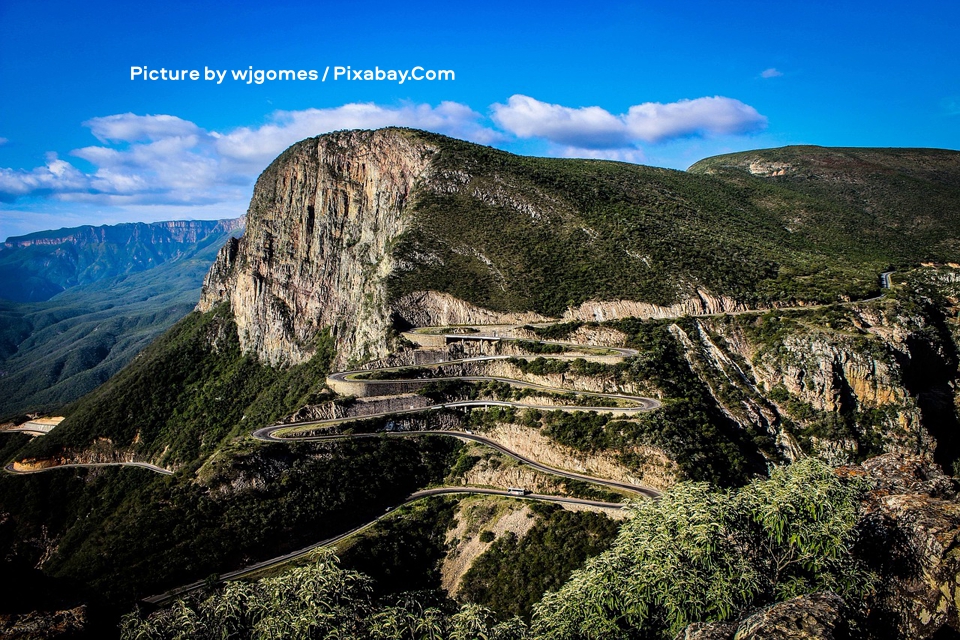
The image above captures the breathtaking Serra da Leba mountain pass, featuring a massive steep rocky cliff face covered in patches of green vegetation that towers dramatically over a series of winding hairpin switchbacks carved into the mountainside, with a paved road snaking down through the rugged terrain under a vivid blue sky dotted with scattered white clouds, while distant mountain ranges stretch across the horizon in the background. This iconic viewpoint is located in Huíla Province in southwestern Angola. Picture by wjgomes / Pixabay.Com.
Physical geography and terrain
Angola features three main topographic regions:
- Coastal lowlands — A narrow, arid to semi-arid plain stretches along the Atlantic, varying in width from 15–200 km (about 10–125 mi). It includes low plains, terraces, sandy beaches, and rocky cliffs, becoming more desert-like in the south (influenced by the Namib Desert extension).
- Escarpment and highlands — Inland from the coast, the land rises abruptly through hills and mountains to a great escarpment. Key features include the Bié Plateau (central, rising above 1,500 m / 5,000 ft), Malanje Highlands (north-central), and Huíla Plateau (south).
- Interior high plateau (Planalto) — This vast, gently sloping plateau covers much of the eastern two-thirds of the country at elevations of 1,000–1,500 m (3,300–4,900 ft), with higher peaks. It slopes gradually eastward toward the Congo and Zambezi basins.
Highest point: Mount Moco (Portuguese: Morro de Môco or Morro do Moco), at 2,620 m (8,596–8,600 ft), located in Huambo Province in the western part of the central highlands, approximately 70 km (43 mi) west of the city of Huambo. It sits within the Angolan montane forest-grassland mosaic ecoregion and has a topographic prominence of about 1,513 m. The mountain is known for its rugged terrain, grasslands, and patches of Afromontane forest. It is a popular destination for hiking, birdwatching, and paragliding, with trails (such as the Mount Moco Trail) typically involving a steep ascent through red-dirt paths and grasslands, often taking 2.5–3 hours to the summit from trailheads like Kanjonde village. The summit offers panoramic views over the rolling highlands and is marked by a sign. The area supports rich biodiversity, including endemic and endangered bird species such as Swierstra’s Spurfowl (Pternistis swierstrai).
Climate
Angola has a primarily tropical climate with distinct wet and dry seasons, modified by elevation, the cold Benguela Current (which cools the coast and reduces rainfall), and the Intertropical Convergence Zone.
- Coastal areas: Arid to semi-arid; Luanda receives only about 330 mm (13 in) of rain annually.
- Northern and central highlands: Wetter, with up to 1,450 mm (57 in) or more; tropical highland conditions.
- South and southeast: Hotter, drier savanna or semi-desert conditions.
- Cabinda and far north: Humid tropical rainforest influences.
Rainy season generally runs September–May in the north and December–March in the south. Droughts are common, especially in the south. Temperatures are moderate due to elevation, averaging 19–26°C (66–79°F) depending on location.
Rivers and drainage
Angola’s central high plateau acts as a major watershed divide, feeding several important river systems that drain into the Atlantic Ocean, the Congo Basin, the Zambezi system, and the inland Okavango Basin. The country’s rivers are vital for hydroelectric power, irrigation, biodiversity, and local livelihoods, though many are seasonal or interrupted by rapids.
Major rivers
- Kwanza (Cuanza) River — Angola’s longest river entirely within its borders, stretching approximately 960 km (600 mi). It rises in the Bié Plateau (central highlands) and flows northward before curving westward to empty into the Atlantic Ocean south of Luanda. Its basin covers about 152,570 km². The lower course is partially navigable (roughly 200–250 km from the mouth), and it features several large dams, including Cambambe, Capanda, and Laúca, which generate significant hydroelectric power for the country. The river supports diamond mining, agriculture, and rich biodiversity along its course. Angola’s national currency, the kwanza, is named after this river.
- Cunene (Kunene) River — Approximately 945 km (587 mi) long, rising near Huambo in the central plateau. It flows southward, then turns westward, forming part of the Angola-Namibia border before reaching the Atlantic. Notable features include the Ruacana Falls and Epupa (Montenegro) Falls, as well as the Matala Dam and Ruacana hydropower projects. It supports irrigation and crosses from highlands into arid zones, creating floodplains in its lower reaches.
- Cubango (Okavango) River — Originates in the Angolan highlands and flows southeast, forming part of the border with Namibia before continuing into Botswana as the Okavango River. Together with its major tributary, the Cuito River, it provides most of the water for the famous Okavango Delta in Botswana. This system is internationally significant for its biodiversity and is one of Africa’s more pristine river basins, often called the “Source of Life” (Lisima Iya Mwono) by local communities.
Other notable rivers include:
- Northern tributaries of the Congo River system (such as the Cuango/Kwango, Cassai/Kasai, and others), which drain the northeast.
- Southeastern rivers feeding the Zambezi River basin (e.g., Cuando/Kwando, Lungué-Bungo).
- Smaller coastal rivers like the Longa, Cuvo, and Bengo.
The rivers exhibit strong seasonal variation due to Angola’s wet-dry climate, with higher flows during the rainy season. Many support important wetlands, but development (dams, mining, agriculture) and climate variability pose ongoing challenges for sustainable management.
Natural resources and vegetation
Angola is rich in resources: petroleum (offshore), diamonds, iron ore, phosphates, copper, gold, bauxite, uranium, and more.
Vegetation varies widely:
- Coastal desert/semi-desert
- Savanna and woodlands on the plateau
- Montane forests and grasslands in highlands
- Tropical rainforests in the north and Cabinda
The country hosts representatives of several African biomes and ecoregions.
Provinces and human geography
Angola is divided into 18 provinces. Major cities include the capital Luanda (on the northern coast), Huambo, Benguela, and Lubango. Population concentrates in the north and central highlands, with vast interior and southern areas more sparsely populated.
Angola’s geography shapes its economy (oil and diamonds), agriculture potential (highlands), and challenges (droughts, coastal aridity). Its varied landscapes—from Atlantic beaches and escarpments to vast plateaus and rainforests—offer significant biodiversity and tourism potential.