Africa is the world’s second-largest continent (after Asia), covering approximately 30.37 million square kilometers (about 11.7 million square miles), or roughly 20% of Earth’s total land surface. It stretches approximately 8,000 km (5,000 miles) from north to south and 7,400 km (4,600 miles) from east to west. The continent is bounded by the Mediterranean Sea to the north, the Red Sea and Indian Ocean to the east, and the Atlantic Ocean to the west. Its northernmost point is near Cape Blanc in Tunisia, its southernmost at Cape Agulhas in South Africa, its easternmost at Cape Guardafui in Somalia, and its westernmost at Cape Verde in Senegal.
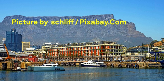
The image above captures a vibrant waterfront scene at the V&A Waterfront in Cape Town, South Africa, in a bustling harbor under a clear, bright blue sky, with calm blue water in the foreground reflecting the structures along the dock. Several boats are moored at the piers, including a sleek white yacht on the left and a larger white-and-blue ferry or passenger vessel nearby, while modern buildings line the shore, featuring a prominent long red-and-white multi-story structure with numerous windows and balconies, flanked by taller glass skyscrapers to the left and other commercial buildings. In the background, a massive, flat-topped mountain rises dramatically behind the cityscape, its rocky slopes and plateau dominating the horizon and adding a striking natural contrast to the urban development. Picture by schliff / Pixabay.Com.
The Equator divides Africa almost equally, placing most of the continent in the tropics (between the Tropic of Cancer and Tropic of Capricorn). This positioning contributes to its diverse climates and ecosystems. Africa has a relatively straight coastline with few deep inlets or bays, resulting in a total coastline length of about 30,500 km—shorter than Europe’s despite the continent’s vast size. It was historically connected to Asia via the Sinai Peninsula until the Suez Canal was built.
Major physical regions
Africa features eight primary physical regions, each with distinct landscapes, climates, flora, and fauna:
- Sahara Desert: The world’s largest hot desert, covering approximately 9.2 million square kilometers (about 3.55 million square miles). This makes it roughly the size of the United States (including Alaska) or China, and it spans roughly 4,800 km east to west and 1,800 km north to south. It dominates northern Africa, stretching from the Atlantic Ocean in the west to the Red Sea in the east, and borders the Mediterranean Sea and Atlas Mountains to the north and the semi-arid Sahel to the south. The Sahara occupies about 25–31% of Africa’s total land area and encompasses parts of 11 countries, including Algeria, Libya, Egypt, Sudan, Chad, Niger, Mali, Mauritania, Morocco, Tunisia, and Western Sahara. The landscape is remarkably varied and not composed entirely of sand. Only about 25% of the surface consists of sand sheets and dunes (known as ergs or sand seas), some of which feature towering pyramidal dunes reaching heights of nearly 500 feet (150 meters) or more, with the tallest in Algeria exceeding 1,300 feet in places. The majority of the desert comprises rocky plateaus (hamadas), extensive gravel-covered plains (regs or serirs), dry valleys (wadis), salt flats (chotts), shallow basins, and scattered mountain massifs. Notable high points include the extinct volcano Emi Koussi (Mount Koussi) in the Tibesti Mountains of Chad at 3,415 meters (11,204 feet), while the lowest is the Qattara Depression in Egypt at about 133 meters (436 feet) below sea level. Oases—vital pockets of vegetation and water sustained by underground aquifers—dot the region and have historically supported human settlements, trade routes, and agriculture (such as date palms). The Sahara experiences extreme climatic conditions: daytime temperatures often exceed 40–50°C (104–122°F) in summer, with record highs near 58°C, while nights can drop to freezing or below. Annual rainfall is minimal, with large areas receiving less than 25 mm (1 inch) per year. Winds shape much of the terrain through erosion and dune formation, and rare phenomena like “singing” or booming sands occur in certain dune fields.
- Sahel: A semi-arid transitional zone south of the Sahara, characterized by grasslands and savannas that blend into desert conditions. It experiences variable rainfall and is prone to desertification.
- Ethiopian Highlands: A rugged, elevated region in eastern Africa with volcanic peaks and deep valleys, part of the Great Rift Valley system. This area includes some of the continent’s highest elevations.
- Savannas: Vast tropical grasslands covering much of central and southern Africa, supporting iconic wildlife like Lions (Panthera leo), Savanna Elephants (Loxodonta africana), and giraffes. They feature scattered trees and seasonal rains.
- Congo Rainforests (and other rainforests): Dense equatorial forests, particularly in the Congo Basin—the world’s second-largest tropical rainforest after the Amazon. The Congo Basin rainforest spans approximately 1.8–2 million square kilometers of dense forest cover (with the broader basin ecosystem covering around 3.7 million square kilometers), stretching across six main countries: the Democratic Republic of the Congo (which holds about 60% of the forest), Republic of the Congo, Cameroon, Gabon, Equatorial Guinea, and the Central African Republic. It accounts for over 70% of Africa’s tropical forests and forms a vast mosaic of lowland rainforests, swamps, flooded forests, and riverine habitats drained by the mighty Congo River system. These forests receive heavy year-round rainfall, typically averaging 1,200–2,000 mm (47–79 inches) or more annually, with some areas experiencing even higher precipitation and minimal seasonal variation. Temperatures remain consistently warm, usually between 20–30°C (68–86°F), creating ideal conditions for luxuriant growth. The canopy is multilayered, with tall emergent trees reaching 40–60 meters, a dense middle story, and a shaded understory. Biodiversity is extraordinary: the region harbors over 10,000 plant species (including more than 600 tree species, with about 30% endemic), at least 400 mammal species (such as Forest Elephants (Loxodonta cyclotis), Western Lowland Gorillas (Gorilla gorilla gorilla), Mountain Gorillas (Gorilla beringei beringei), Chimpanzees (Pan troglodytes), Bonobos (Pan paniscus), and Okapis (Okapia johnstoni)), over 1,000 bird species, and around 700 fish species in its rivers and wetlands. It is home to one in five of Earth’s living species and serves as a critical global carbon sink, storing tens of billions of tons of carbon. In addition to the vast Congo Basin, Africa has other significant rainforests, though they are much smaller and more fragmented. The Guinean Forests of West Africa (also known as Upper and Lower Guinean forests) extend along the coast from Sierra Leone and Guinea through Liberia, Côte d’Ivoire, Ghana, Nigeria, and into southwestern Cameroon. These forests are biodiversity hotspots but have lost a large portion of their original cover due to human activity, with remaining patches supporting unique primates, birds, and plants. Smaller pockets of rainforest or montane forests also exist in the Ethiopian Highlands, the Eastern Arc Mountains, and along parts of the Indian Ocean coast (Coastal Forests of Eastern Africa). Madagascar hosts distinct humid forests with high endemism, though they are not directly connected to the mainland systems.
- African Great Lakes: A cluster of large freshwater lakes in eastern Africa, including Lake Victoria (Africa’s largest lake), Lake Tanganyika, and Lake Nyasa. They lie along the Great Rift Valley and are vital for local ecosystems and human populations.
- Swahili Coast: The eastern coastal region along the Indian Ocean, known for its coral reefs, islands, and historical trading ports.
- Southern Africa: Includes high plateaus, the Kalahari and Namib Deserts, and mountain ranges like the Drakensberg. It features varied terrain from arid zones to fertile highlands.
The continent’s interior is dominated by a vast plateau with an average elevation of around 600 meters (2,000 feet). Higher elevations are concentrated in the east and south, while lower areas are more common in the west and north. Africa has limited extremely high or low terrain compared to other continents.
Mountains and highlands
Africa’s highest peak is Mount Kilimanjaro (5,895 meters or 19,341 feet) in Tanzania, a dormant volcano often capped with snow despite its equatorial location. Other notable ranges include the Atlas Mountains in the northwest (Morocco, Algeria, Tunisia), the Ethiopian Highlands, the Drakensberg in the south, and peaks along the Great Rift Valley. The Rwenzori Mountains (between Uganda and the Democratic Republic of the Congo) are sometimes called the “Mountains of the Moon.”
Rivers and lakes
Africa’s rivers and lakes are among its most vital geographical features. They provide essential water for drinking, agriculture, and industry; generate hydroelectric power; and have historically facilitated trade, transportation, and the rise of civilizations. The continent’s major river systems drain vast basins and sustain millions of people, while the African Great Lakes hold a significant portion of the world’s unfrozen freshwater.
Major rivers include:
- The Nile River (about 6,650 km or 4,130 miles long), the world’s longest river. It originates from streams feeding into Lake Victoria (White Nile) and the Ethiopian Highlands (Blue Nile), which merge in Sudan. Flowing northward through 11 countries, it empties into the Mediterranean Sea via a fertile delta in Egypt. The Nile has been central to ancient civilizations and remains crucial for irrigation and water supply in arid regions.
- The Congo River (about 4,700 km or 2,920 miles long), Africa’s second-longest river and one of the most voluminous in the world (second only to the Amazon in discharge). It drains the massive Congo Basin, crosses the Equator twice, and flows through dense rainforests before reaching the Atlantic Ocean. It is notable for its depth, navigable sections (despite cataracts), and rich biodiversity, including many endemic fish species.
- The Niger River (about 4,180–4,200 km or 2,600 miles long), the third-longest in Africa. It begins in the Guinea Highlands, follows an unusual crescent-shaped path through West Africa (including the inland delta in Mali), and empties into the Gulf of Guinea in Nigeria. It supports agriculture and trade in the Sahel and surrounding savannas.
- The Zambezi River (about 2,574 km or 1,600 miles long), the fourth-longest and the longest eastward-flowing river in Africa. Rising in Zambia, it flows through several southern African countries and is renowned for Victoria Falls—one of the world’s largest and most spectacular waterfalls. It drains into the Indian Ocean in Mozambique and is important for hydropower (including the Kariba Dam) and wildlife.
Other notable rivers include the Orange River in southern Africa.
The Nile Delta is a fertile region where the river fans out before entering the Mediterranean.
Africa is also home to the African Great Lakes system, located primarily along the East African Rift Valley. Collectively, these lakes hold over 25% of the world’s surface freshwater (approximately 31,000 cubic kilometers), support productive activities that provide food and livelihoods for millions, and host extraordinary biodiversity—including many endemic fish species. Key lakes include:
- Lake Victoria: Africa’s largest lake by surface area (about 68,800 km² or 26,600 square miles) and the second-largest freshwater lake in the world by area. Shared by Uganda, Tanzania, and Kenya, it is relatively shallow (maximum depth around 80–84 meters) but has an extensive shoreline. It serves as the primary source of the White Nile.
- Lake Tanganyika: The world’s longest freshwater lake (about 673 km) and the second-deepest (maximum depth around 1,470 meters). Shared by Tanzania, the Democratic Republic of the Congo, Burundi, and Zambia, it has exceptional water clarity and harbors a high number of unique species.
- Lake Nyasa (also known as Lake Malawi): The third-largest of the Great Lakes, shared by Malawi, Tanzania, and Mozambique. It is notably deep (up to 700 meters) and renowned for its incredible diversity of cichlid fish—many of which are found nowhere else.
Other important lakes in the system include Albert, Edward, Kivu, and Turkana. These water bodies are critical for regional ecosystems, but they also face challenges such as pollution and overfishing.
Climate and vegetation
Africa’s climates range from hot desert (Sahara) and semi-arid (Sahel) to tropical rainforest (Congo Basin), savanna, and Mediterranean (northern and southern tips). Much of the continent experiences wet and dry seasons rather than four distinct seasons. Over one-third of Africa consists of drylands or deserts. Vegetation includes desert scrub, grasslands, dense forests, and highland meadows. Snow can occur on high mountains like Kilimanjaro, even near the Equator.
Political geography
Africa comprises 54 recognized sovereign countries and several dependent territories or partially recognized states. The largest by area is Algeria; the most populous is Nigeria. The continent is incredibly diverse culturally and linguistically, with over 1,000 languages spoken.
Africa’s geography has profoundly influenced human history, migration, trade (e.g., along the Nile and Sahel routes), and biodiversity. It supports unique wildlife in savannas and rainforests while presenting challenges like arid zones and variable rainfall.