Algeria, officially the People’s Democratic Republic of Algeria, is the largest country in Africa and the tenth-largest in the world. It spans approximately 2,381,740 square kilometers (919,590 square miles), with more than 80% consisting of desert. Located in North Africa, it forms a key part of the Maghreb region.
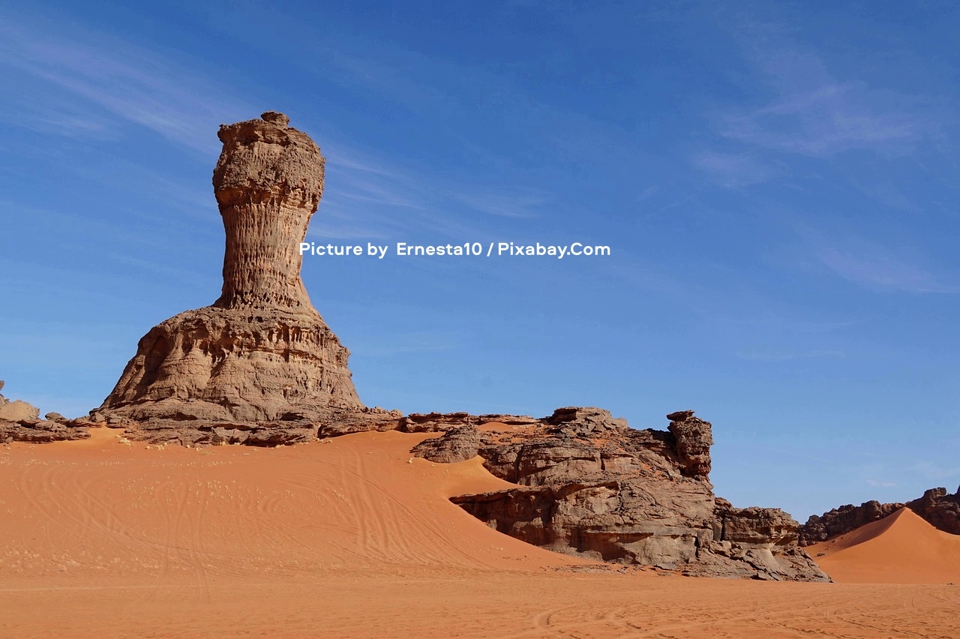
A striking desert landscape unfolds under a vast, clear blue sky with faint wisps of clouds, dominated by a towering, weathered rock formation known as a mushroom rock or pedestal rock that rises prominently from the orange sands like a natural monument in Algeria’s Sahara Desert, its base broad and layered with eroded textures while its narrower upper section culminates in a rugged cap. Surrounding it are rolling dunes marked with gentle ripples and tire tracks, along with additional rocky outcrops and cliffs in the midground, creating a scene of arid isolation and geological wonder. Picture by Ernesta10 / Pixabay.Com.
Location and borders
Algeria lies on the Mediterranean coast, bordered to the north by the Mediterranean Sea (with a coastline of about 998–1,200 km). It shares land borders with Morocco and Western Sahara to the west, Tunisia and Libya to the east, and Niger, Mali, and Mauritania to the south.
Its vast size stretches roughly 2,100 km north-south and 2,400 km east-west. The capital, Algiers, sits on the central northern coast. Most of the population (over 90%) lives in the northern coastal region, while the interior and south remain sparsely populated.
Physical features and topography
Algeria’s landscape divides into three main parallel zones from north to south: the Tell, the High Plateaus, and the Sahara.
1. The Tell (northern coastal region):
The Tell (Arabic for “hill”) is Algeria’s fertile heartland and most densely populated zone, home to the majority of its cities and inhabitants. This narrow coastal strip, ranging from about 50–100 miles (80–160 km) deep and up to 130–320 km wide in places, extends from the Moroccan border eastward to the mountains of Grande Kabylie and the Bejaia Plain, ending around the Soummam River.
It consists of hills, plains, discontinuous coastal plains, and the Tell Atlas mountain ranges, interspersed with valleys and basins. Key agricultural areas include the gentle hills west of Algiers, the Mitidja Plain (once a malarial swamp, now highly productive), the Chelif River valley, and the Bejaia Plain. The western parts feature rolling hills ideal for farming, while the east is more rugged.
The region enjoys a Mediterranean climate with adequate rainfall (often 400–1,000 mm annually in higher areas), supporting rich farmland, orchards, and vegetation. However, interior valleys can suffer from aridity and summer heat. Major cities like Algiers, Oran, and Annaba are located here. The Tell incorporates the full length of Algeria’s Mediterranean coastline and forms a vital barrier and transition zone.
2. The High Plateaus (Hauts Plateaux):
Situated between the Tell Atlas and Saharan Atlas, the High Plateaus form a semi-arid transitional zone of undulating, steppe-like plains stretching over 600 km from the Moroccan border eastward. Elevations average 900–1,300 meters in the west, dropping to around 400 meters in the east.
Covered by alluvial debris from eroded mountains, the landscape includes vast rocky expanses, intermittent ridges, salt lakes (chotts), and steppe vegetation dominated by esparto grass. It serves primarily as rangeland for sheep and goats, with limited agriculture where water is available. The climate features extremes of temperature—cold winters and hot summers—with low rainfall, making parts feel like an extension of the Sahara. Scattered clumps of trees and bush provide some pasture.
3. The Sahara Desert:
Occupying over 80% of Algeria’s territory south of the Saharan Atlas, the Algerian Sahara is a vast, ancient platform of basement rock—largely horizontal and uniform. It encompasses enormous sand dunes (ergs like the Grand Erg Oriental and Occidental), rocky plateaus (hamadas), gravel plains (reg), and dry riverbeds (oueds).
The region is extremely arid, with some areas receiving virtually no rain for years. Daytime temperatures often soar above 40–50°C, while nights can drop sharply. Oases, supported by underground water, allow limited settlement and date palm cultivation. Prehistoric rock art sites, such as those in Tassili n’Ajjer (a UNESCO site), highlight its rich cultural heritage. Hydrocarbon resources (petroleum and natural gas) are concentrated here, forming the backbone of Algeria’s economy.
Mountain ranges:
The Atlas Mountains dominate northern Algeria and consist of two main parallel chains formed by the collision of the African and Eurasian tectonic plates.
- The Tell Atlas (or Maritime Atlas) runs close to the coast, stretching over 1,500 km across northern Algeria (with extensions into Morocco and Tunisia). It features multiple distinct ranges, gorges, valleys, and peaks often exceeding 2,000 meters (e.g., in the Kabylie and Aurès regions). The highest point in this system is Lalla Khedidja. It creates a natural barrier, influencing rainfall patterns and supporting forests on northern slopes.
- The Saharan Atlas, higher and more continuous in parts, lies further south (e.g., massifs like the Ksour, Amour, and Oulad Nail). It receives more rainfall than the plateaus and provides grazing land, with watercourses feeding oases along the desert edge (such as Biskra and Laghouat). In the east, the ranges merge into the Aurès Mountains.
In the far south, the ancient Hoggar (Ahaggar) Mountains rise dramatically from the Sahara floor as a highland region covering about 550,000 km². Composed of granite, metamorphic rock, and volcanic formations, they feature jagged peaks, basalt structures, and deep canyons. Mount Tahat, at 2,908–3,003 meters, is Algeria’s highest point. The area has a relatively temperate highland climate compared to the surrounding desert, with occasional frost or snow at elevation, and supports unique ecosystems and Tuareg nomadic culture.
Climate
Algeria’s climate varies sharply by region:
- Northern Coast (Mediterranean): Mild, wet winters and hot, dry summers.
- High Plateaus: Semi-arid with greater temperature extremes.
- Sahara: Hyper-arid, with the hot sirocco wind common.
Environmental challenges
The country faces significant water stress, desertification, and seismic risks in mountainous areas, challenges that are intensified by population growth and historical land-use patterns.
Algeria is classified as a water-scarce nation, with per capita freshwater availability having dropped dramatically from around 1,500 m³ in the early 1960s to approximately 430 m³ today, and projections indicate it could fall below 220 m³ by 2050. This scarcity stems from low and irregular rainfall (much of which evaporates quickly), over-extraction of groundwater, siltation of dams, and rising demand from agriculture (which consumes the bulk of water resources), urbanization, and industry. Northern coastal regions experience periodic droughts, while the High Plateaus and southern areas rely heavily on non-renewable aquifers. In response, the government is heavily investing in seawater desalination plants, aiming for these to supply up to 60% of drinking water needs by 2030, alongside wastewater recycling initiatives.
Desertification affects large parts of the country, particularly the High Plateaus and steppe regions, where thousands of hectares of productive land are lost annually to soil degradation, erosion, and the southward advance of arid conditions. Overgrazing, deforestation, unsustainable farming practices, and prolonged droughts exacerbate the problem, reducing biodiversity, lowering agricultural yields (with risks of up to 50% decline in some grains), and threatening food security and rural livelihoods. The High Plains steppe zone is especially vulnerable.
Seismic risks are prominent in the northern mountainous zones, especially along the Tell Atlas, due to Algeria’s location at the convergent boundary between the African and Eurasian tectonic plates. The country has a history of destructive earthquakes, including the 1980 El Asnam (Chlef) event (magnitude 7.1) that killed thousands and the 2003 Boumerdès quake. Moderate to high seismic hazard exists in populated northern areas, prompting ongoing efforts in building codes, early warning systems, and disaster preparedness.
These interconnected challenges—water scarcity, advancing desertification, and earthquake vulnerability—pose serious risks to Algeria’s economy, infrastructure, agriculture, and energy sector, driving national strategies focused on climate resilience, sustainable resource management, and disaster risk reduction.
Natural resources and environment
Significant reserves of petroleum, natural gas, iron ore, phosphates, uranium, lead, and zinc—mostly in the Sahara—complement fertile coastal farmlands and unique desert ecosystems.
Algeria’s vast and contrasting terrain—from the verdant, hilly Tell to the majestic Atlas ranges and the immense golden Sahara—defines its economy, culture, and challenges, blending Mediterranean vitality with desert resilience.