Botswana is a landlocked country in Southern Africa, renowned for its vast wilderness, stable democracy, and remarkable geographic diversity. Situated north of South Africa, it occupies a significant portion of the Kalahari Basin and features dramatic contrasts between arid deserts, expansive wetlands, and salt pans.
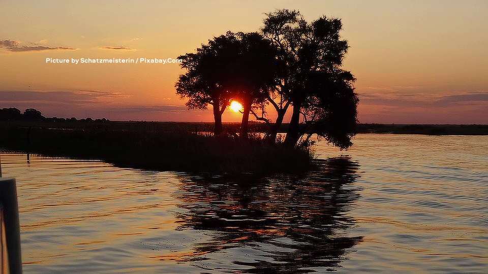
A breathtaking sunset unfolds over the Chobe River in Botswana, where the glowing orange sun dips low on the horizon, partially framed by the dark silhouettes of trees clustered on a small grassy island or riverbank. The calm waters in the foreground reflect the warm hues of the sky and the tree outlines, creating a serene and mirror-like effect across the rippling surface, while the distant landscape fades into soft gradients of orange and purple under scattered clouds. This iconic scene captures the natural beauty of Chobe National Park, a renowned wildlife haven in northern Botswana famous for its dramatic riverine sunsets. Picture by Schatzmeisterin / Pixabay.Com.
Location, size, and borders
Botswana lies roughly between latitudes 18°S and 27°S and longitudes 20°E and 30°E. It covers approximately 581,730 square kilometers (224,610 square miles), making it slightly larger than France and the 48th-largest country in the world by area.
As a landlocked nation, it shares borders with Namibia to the west and north, South Africa to the south and southeast, Zimbabwe to the northeast, and a very short border with Zambia. The country’s eastern and southern borders partly follow river courses like the Limpopo, while western boundaries often align with lines of latitude and longitude through the Kalahari.
Topography and major regions
Botswana sits on a vast, elevated plateau with an average altitude of about 1,000–1,100 meters above sea level. The terrain is predominantly flat to gently undulating, with limited hilly areas. The highest point reaches around 1,489 meters in the Tsodilo Hills in the northwest.
The country divides into several key natural regions:
- The Kalahari Desert: This semi-arid sandy savanna covers about 70% of Botswana, dominating the central, southern, and western parts. It supports grasses, shrubs, and acacia trees in many areas.
- The Okavango Delta: In the northwest, this is one of the world’s largest inland deltas, a biodiversity hotspot and UNESCO World Heritage site.
- Makgadikgadi Pans: Located in the north-central region, these are among the largest salt pan complexes in the world, remnants of an ancient mega-lake that once covered a vast area of central Botswana. The system includes prominent pans such as Sua (Sowa) Pan and the larger Ntwetwe Pan, together spanning over 12,000–30,000 km² depending on how the broader complex is defined. In the dry season, they form vast, shimmering white salt flats with a hard clay crust, creating some of the most expansive, featureless horizons on Earth. During the wet season (typically following summer rains), they transform into shallow lakes and grassy plains, attracting massive flocks of flamingos—one of Southern Africa’s most important breeding sites—and hosting one of the continent’s great wildlife spectacles: enormous herds of Plains Zebra (Equus quagga) and Blue Wildebeest (Connochaetes taurinus) that migrate across the region, pursued by predators like Lions (Panthera leo), Cheetahs (Acinonyx jubatus), and Spotted Hyenas (Crocuta crocuta). Resident species include African Savanna Elephants (Loxodonta africana), Southern Giraffes (Giraffa giraffa), and various antelopes. The pans are protected in areas such as Makgadikgadi Pans National Park and Nxai Pan National Park, with iconic African Baobabs (Adansonia digitata) dotting the landscape as landmarks.
- Eastern and Northern Savannah: These greener zones contrast sharply with the arid interior. The Eastern Savannah (often called the Hardveld) features rocky outcrops, river valleys (including parts of the Limpopo system), and more fertile soils with higher rainfall than the Kalahari. This supports denser tree and bush savannah vegetation, including mopane and acacia woodlands, making it suitable for agriculture and home to most of Botswana’s population and major towns like Gaborone and Francistown. The Northern Savannah extends from the fringes of the Okavango Delta toward the borders with Zimbabwe and Zambia. It includes lush tree savannah, woodland areas, floodplains, and riverine environments associated with the Chobe, Linyanti, and Kwando rivers. This region features diverse habitats ranging from mopane woodlands to palm-fringed areas and supports exceptional wildlife concentrations, particularly in Chobe National Park and private concessions. It serves as vital corridors for African Savanna Elephant migrations and hosts high densities of African Buffalo (Syncerus caffer), antelope, and predators. The northern reaches offer some of Botswana’s most secluded and pristine wilderness.
Rivers are mostly seasonal except for the Okavango, Chobe (which flows into the Zambezi), and parts of the Limpopo system.
Climate
Botswana has a semi-arid to subtropical climate influenced by its high altitude and inland position. Rainfall is highly variable and decreases from northeast to southwest.
Natural resources and conservation
The landscape supports rich mineral resources (notably diamonds) and exceptional biodiversity. Nearly 30% of Botswana’s land is protected. These areas are vital for Africa’s iconic megafauna.
Botswana’s geography—blending harsh arid expanses with life-giving wetlands and savannahs—creates one of Africa’s most unique and resilient ecosystems. From the ancient rock art of the Tsodilo Hills to the modern conservation efforts preserving its wilderness, the country exemplifies the beauty of Southern Africa’s interior.