South America is the fourth-largest continent by land area, covering approximately 17.8 million square kilometers (about 6.88 million square miles), or roughly 12% of Earth’s land surface. It forms the southern part of the Americas, connected to North America via the narrow Isthmus of Panama. The continent stretches from about 12°N latitude (near the Caribbean) to 55°S at Cape Horn, mostly in the Southern Hemisphere, and is bounded by the Caribbean Sea to the north, the Atlantic Ocean to the east and northeast, the Pacific Ocean to the west, and the Drake Passage to the south (separating it from Antarctica). Its shape is roughly triangular—broad in the north and tapering southward.
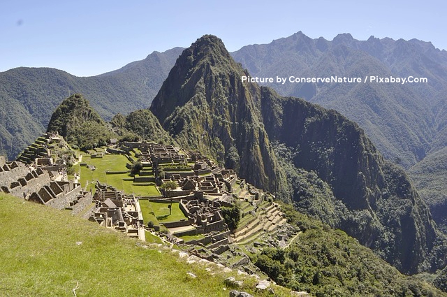
The image above captures the breathtaking ruins of Machu Picchu nestled high in the Andes Mountains of Peru, with ancient stone terraces and structures sprawling across a lush green ridge under a clear blue sky. In the background, the iconic jagged peak of Huayna Picchu rises dramatically, surrounded by steep, forested mountain slopes that stretch into the distance, while a few small figures of visitors can be seen exploring the grassy plazas and pathways among the well-preserved Inca walls and foundations. The foreground features a vibrant green hillside dotted with rocks, adding depth to the panoramic view of this historic citadel blending harmoniously with the rugged natural landscape. Picture by ConserveNature / Pixabay.Com.
Countries and human geography
South America includes 12 independent countries: Argentina, Bolivia, Brazil, Chile, Colombia, Ecuador, Guyana, Paraguay, Peru, Suriname, Uruguay, and Venezuela, plus the French overseas department of French Guiana. Brazil is the largest by both area and population (home to nearly half the continent’s people), followed by countries like Colombia, Argentina, and Peru. The total population is approximately 440 million as of 2026, making it the fifth-most populous continent with a relatively low average density of about 25 people per km². Most inhabitants live in coastal areas, major river valleys, or highland cities, while vast interiors (like the Amazon) and southern regions remain sparsely populated. Key cities include São Paulo and Rio de Janeiro (Brazil), Buenos Aires (Argentina), Lima (Peru), and Bogotá (Colombia).
Major physical features
South America’s landscape is dramatically varied, often divided into three main regions: the western mountains and highlands, central river basins and lowlands, and eastern plateaus/highlands, with narrow coastal plains.
- The Andes Mountains: The world’s longest continental mountain range, stretching approximately 8,900 km (5,500 miles) along the western edge of South America from Venezuela in the north to Tierra del Fuego in the south. It spans seven countries (Venezuela, Colombia, Ecuador, Peru, Bolivia, Chile, and Argentina) and varies in width from 200 to 700 km (120 to 430 miles), with an average elevation of about 4,000 m (13,000 ft). Formed by the ongoing subduction of the oceanic Nazca Plate beneath the continental South American Plate, the Andes are geologically young, featuring numerous active volcanoes, frequent earthquakes, deep valleys, high plateaus (such as the Altiplano in Peru and Bolivia), and dramatic peaks. The highest point in the Western Hemisphere is Mount Aconcagua in Argentina at 6,959–6,961 meters (22,831–22,838 feet).
The range acts as a formidable natural barrier, creating strong rain-shadow effects: moist air from the east rises and drops precipitation on the windward slopes (supporting lush forests in places), while the leeward western side often remains arid, contributing to deserts like the Atacama. This vertical relief produces extraordinary biodiversity through altitudinal zonation, with ecosystems shifting rapidly from tropical lowlands to cloud forests, alpine grasslands (páramo), and permanent snow/glaciers at the highest elevations. The Andes support unique endemic species, including plants (with thousands of species), mammals like llamas and alpacas (domesticated by ancient peoples), and birds such as the Andean Condor (Vultur gryphus). They have profoundly shaped human history, serving as the backbone for civilizations like the Inca and providing minerals, freshwater from glaciers and rivers, and agricultural terraces today.
- Eastern highlands and plateaus: To the east of the central lowlands lie two major ancient highland regions: the Brazilian Highlands (also known as the Brazilian Plateau or Planalto) and the Guiana Highlands. These are much older and more eroded than the Andes, consisting primarily of ancient crystalline rocks (igneous and metamorphic), forming rolling hills, dissected plateaus, and low mountain ranges rather than sharp peaks.
The Brazilian Highlands cover a vast area in eastern and central Brazil (extending into parts of Paraguay and Argentina), with average elevations around 1,000 meters (3,300 feet). They feature gently undulating terrain, escarpments, and river-dissected landscapes that support important agricultural regions, including parts of the Cerrado savanna. Major cities like São Paulo and Rio de Janeiro are situated on or near these highlands, which influence drainage patterns for rivers flowing toward the Atlantic.
The smaller but more dramatic Guiana Highlands (or Guiana Shield) lie north of the Amazon River, spanning southern Venezuela, Guyana, Suriname, French Guiana, and northern Brazil. This region is characterized by isolated, flat-topped table mountains called tepuis—erosional remnants of an ancient plateau with sheer vertical cliffs rising hundreds to over 1,000 meters above the surrounding rainforest or savanna. The highest tepui peaks reach around 2,700–2,800 meters (about 9,000 feet), such as Mount Roraima. These highlands are heavily forested in lower areas and give rise to spectacular waterfalls, most famously Angel Falls in Venezuela (the world’s highest uninterrupted waterfall, plunging over 979 meters / 3,212 feet from Auyán-tepui). The Guiana Highlands contribute to the headwaters of major river systems, including parts of the Orinoco and Amazon basins, and host unique endemic species adapted to the isolated tepui summits, which have been compared to “islands in the sky.”
- Central lowlands and river systems: Between the towering Andes to the west and the ancient eastern highlands lies one of the world’s most extensive lowland regions—the vast central lowlands of South America. These broad, relatively flat sedimentary plains and basins cover much of the continent’s interior and act as a giant “bowl” that collects and channels water from the surrounding higher terrain toward the Atlantic Ocean. The lowlands are divided into several major basins, with the Amazon Basin being the dominant feature.
The Amazon Basin is the largest tropical lowland in the world, spanning roughly 7 million km² (about 2.7 million mi²) across Brazil, Peru, Colombia, Ecuador, Bolivia, and Venezuela. It is drained by the mighty Amazon River and its thousands of tributaries. The Amazon River itself is the world’s largest by volume of water discharged (accounting for about one-fifth of all river water entering the oceans) and second-longest (roughly 6,400–6,992 km / 4,000–4,345 miles, depending on measurement methods), originating in the Peruvian Andes and flowing eastward across the continent to empty into the Atlantic. Its enormous watershed supports the planet’s largest tropical rainforest, a dense, biodiverse ecosystem often called the “lungs of the Earth.” The basin’s flat topography results in slow-moving rivers that frequently flood vast areas during the rainy season, creating seasonally inundated forests (várzea) and permanent wetlands. Sediment and nutrients carried from the Andes enrich the soils in floodplain areas, while the interior features nutrient-poor terra firme forests on ancient soils.
North of the Amazon lies the Orinoco River Basin, covering parts of Venezuela and Colombia. The Orinoco River flows about 2,140 km (1,330 miles) from the Guiana Highlands through extensive savanna plains (llanos) before reaching the Atlantic via a broad delta.
To the south, the Paraná-Paraguay River System (also known as the Plata Basin) drains much of southeastern South America, including parts of Brazil, Paraguay, Bolivia, Argentina, and Uruguay. This system includes the Paraná River (one of South America’s longest at about 4,880 km / 3,030 miles when combined with its tributaries) and the Paraguay River. It flows southward into the wide Río de la Plata estuary (River Plate), shared by Argentina and Uruguay. The associated lowlands include the fertile Pampas—vast temperate grasslands in Argentina and Uruguay that are highly productive for agriculture and livestock—and the Gran Chaco, a subtropical region of dry forests, savannas, and wetlands spanning northern Argentina, Paraguay, and Bolivia. These southern lowlands experience more pronounced seasonal temperature variations compared to the tropical north.
The central lowlands are generally low in elevation (mostly under 200–300 meters / 650–1,000 feet), with gentle slopes that facilitate the formation of meandering rivers, oxbow lakes, and extensive floodplains. This topography has made the region a major transportation corridor historically (via rivers) and supports diverse ecosystems ranging from dense rainforests to open savannas and grasslands.
- Other notable features: Narrow coastal plains line the Pacific and Atlantic. Extremes include the Atacama Desert in northern Chile—one of the driest non-polar places on Earth—and the Valdés Peninsula in Argentina (lowest point at about -40 meters / -131 feet), Lake Titicaca (highest navigable lake in the world, on the Peru-Bolivia border), and the windswept plains and glaciers of Patagonia in the south.
The Atacama Desert stands out as a remarkable extreme within South America’s diverse geography. Located primarily in northern Chile along the Pacific coast and west of the Andes, it stretches approximately 1,000–1,600 km (600–1,000 miles) from near the Peru border southward. It covers about 105,000 km² (41,000 mi²), expanding to around 128,000 km² when including the barren lower Andean slopes. This desert plateau lies between the Chilean Coast Range to the west and the Andes to the east, with elevations often exceeding 2,000–3,000 meters (6,500–10,000 feet) in its interior, and features salt flats (salares), stony terrain, sand dunes, pebble fields, and volcanic landscapes. Some areas reach higher, with volcanic peaks surpassing 6,000 meters.
The Atacama is renowned as the driest non-polar desert on the planet, with average annual precipitation often less than 1 mm (0.04 inches) in its core regions—fifty times drier than Death Valley. Certain weather stations have recorded no measurable rainfall for decades or even centuries in recorded history, qualifying parts as a true “hyperdesert.” This extreme aridity results from a combination of factors: the rain-shadow effect of the high Andes, which blocks moist air from the Amazon Basin; the cold Humboldt (Peru) Current offshore, which cools coastal air and creates a persistent temperature inversion that prevents rain-forming clouds; and the influence of the South Pacific high-pressure system. Coastal areas sometimes receive moisture from dense fog (camanchaca), supporting limited “lomas” vegetation on hillsides, but the interior remains nearly barren. Despite the harshness, the desert hosts unique adapted life forms, including specialized plants, insects, and microorganisms, and serves as an important analog for Mars due to its soil chemistry and dryness. It is also a global hub for astronomy, thanks to its exceptionally clear skies, high altitude, and minimal atmospheric interference—home to major observatories like the Atacama Large Millimeter Array (ALMA). Economically, the region is rich in minerals, particularly copper and nitrates.
Climate and biomes
The continent’s wide latitudinal range, combined with elevation changes and ocean influences, produces highly diverse climates and ecosystems:
- Tropical zones dominate the north and Amazon region, with hot, humid conditions and heavy rainfall supporting dense rainforests and savannas.
- Arid zones appear in the Atacama (and smaller pockets elsewhere), caused by cold ocean currents and Andean rain shadows.
- Temperate and cooler climates prevail southward (e.g., the fertile Pampas grasslands in Argentina/Uruguay) and at high elevations, where alpine and tundra-like conditions occur. Southern Chile and Patagonia have wet western slopes and drier eastern steppes due to prevailing westerlies.
Major biomes include the Amazon Rainforest (unparalleled biodiversity), Pantanal wetlands, Cerrado savanna, Pampas, and Patagonian steppe. Vertical zonation in the Andes creates rapid shifts in vegetation with altitude.
Environmental and global significance
South America’s geography underpins its ecological importance: the Amazon serves as a massive carbon sink and biodiversity hotspot, while Andean glaciers and rivers provide freshwater to millions. Challenges include deforestation, mining impacts (notably in the mineral-rich Atacama and Andes), and climate change effects on ice caps and rainfall. These diverse landscapes have shaped human settlement, ancient civilizations (like the Inca), and modern economies (agriculture in the Pampas, resources in the Andes and Amazon).
In essence, South America is a continent of striking contrasts—towering peaks beside vast rainforests, arid deserts next to fertile plains—all packed into a compact but extraordinarily varied landmass that continues to influence global climate, ecology, and culture.