Egypt occupies the northeastern corner of Africa and extends into Asia through the Sinai Peninsula. It has coasts on the Mediterranean Sea to the north and the Red Sea—including the Gulf of Suez and the Gulf of Aqaba—to the east. The Nile runs the length of the country from south to north. Libya lies to the west, Sudan to the south (the Hala’ib Triangle remains disputed), and Israel and the Gaza Strip to the northeast.
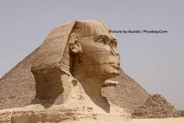
the photograph above captures the Great Sphinx of Giza in a close three-quarter view, its weathered limestone head and headdress dominating the frame as it faces toward the right, with the damaged nose and time-worn facial features clearly visible against a pale, hazy sky. Behind the massive recumbent body, a large pyramid rises on the left while a more eroded pyramid structure appears on the right, both set in the sandy desert terrain of the Giza plateau under even daylight. Photograph by ibulski / Pixabay.Com.
Published area figures vary slightly by source. Widely used totals range from about 1,001,450 km² to 1,010,408 km² (roughly 387,000–390,000 sq mi). The longest north–south span is about 1,420 km (880 mi); the longest east–west span is about 1,275 km (792 mi). Coastline estimates also differ: many official summaries give about 2,450 km, while counts that treat the Gulfs of Suez and Aqaba more fully put the figure above 2,900 km. Egypt’s exclusive economic zone is commonly listed at about 263,451 km² (101,719 sq mi).
The country is divided into 27 governorates. Nine lie in Lower Egypt in the Nile Delta, ten in Upper Egypt along the Nile from Cairo to Aswan, and five are frontier governorates covering Sinai and the deserts east and west of the river. The remaining governorates include the great urban and canal-zone units around Cairo, Alexandria, Port Said, Ismailia, and Suez.
A desert country shaped by one river
Egypt is overwhelmingly desert. Only a few percent of the land is cultivated and permanently settled. Older summaries often cite about 35,000 km², or roughly 3.5 percent of the national area; official agricultural figures are higher once reclaimed desert land is included, on the order of 9–10 million feddans (about 40,000 km²), still a small share of the map. Most of the territory belongs to the vast desert belt that stretches from the Atlantic across North Africa into southwest Asia.
Despite that aridity, Egypt is not empty. The Nile Valley and Nile Delta cover only about 4–5 percent of the country, yet they support the great majority of the population—commonly estimated at about 95 percent, and in some accounts as high as 99 percent when the canal cities are included—and contain almost all of the old arable land. Egypt ranks among the world’s most water-stressed countries. Exact place on global lists depends on the index used, but the cause is the same: almost all usable freshwater comes from a single river shared with upstream states.
Geologically, the country falls into four major physical regions: the Nile Valley and Delta, the Western Desert, the Eastern Desert, and the Sinai Peninsula.
The Nile Valley and Delta
The Nile Valley and Delta form what is often called the largest oasis on Earth—a rhetorical description, but a fair one. Without the topographic channel that carries the river across the Sahara, Egypt would be almost entirely uninhabitable desert.
Within Egypt the Nile flows northward for some 1,600 km from the Sudanese frontier to the Mediterranean. Its water is supplied by three principal sources: the White Nile, the Blue Nile, and the Atbara.
The shares below are long-term averages from classic naturalized records. They vary from year to year, and dams have since changed the timing of water and the delivery of silt.
- In the high-water season the Blue Nile can provide around 68 percent of peak monthly flow, the Atbara about 22 percent, and the White Nile only about 10 percent.
- In the low-water season the White Nile may supply more than 80 percent, the Blue Nile about 17 percent, and the Atbara almost none.
Before the Aswan High Dam was completed in 1970–71, the White Nile kept the Egyptian reach flowing year-round, while the Blue Nile and Atbara’s summer floods overflowed the banks and laid down fertile silt. The great flood usually arrived in August–October, though it could begin as early as June at Aswan and linger into January.
The White Nile
The White Nile is the Nile’s long, steady arm. Its most distant headwaters are usually traced to the Kagera system in the highlands of Burundi and Rwanda, which drain into Lake Victoria, the world’s second-largest freshwater lake. The Nile proper is conventionally said to leave Lake Victoria at Jinja in Uganda. From there the Victoria Nile passes through Lake Kyoga and over falls and rapids, including Murchison Falls, into Lake Albert. The Albert Nile then enters South Sudan at Nimule.
From Nimule to Juba—about 190 km—the river is called the Bahr al-Jabal, or Mountain Nile. It drops through gorges and rapids, including the Fula Rapids, and is not commercially navigable. Below Juba the slope collapses. In its course of about 1,600 km from Juba to Khartoum the river descends only some 75 m. Much of that distance is the Sudd, a vast papyrus swamp whose Arabic name means “barrier.”
The Sudd is the White Nile’s great filter and tax. The river enters the marshes with an annual discharge of roughly 23 km³ and leaves with about 10 km³; half the water is lost to evaporation and seepage. North of the Sudd the Bahr al-Ghazal adds about 3 km³. Above Malakal the Sobat, formed mainly by the Baro and Akobo from the Ethiopian Highlands and the Pibor from South Sudan, restores about 10 km³. The White Nile thus leaves South Sudan with roughly as much water as it had before the Sudd, but with a different chemistry and almost no coarse sediment. The swamps trap sand and gravel; what continues downstream is mostly clear, quartz-rich water.
From Malakal to Khartoum the White Nile in the narrow sense is a wide, shallow, sluggish stream some 800 km long, often fringed with swamp, navigable year-round, and without major tributaries. Including the Mountain Nile, the White Nile system is often given as about 2,080 km. Its basin is enormous—on the order of 1.7 million km², about half the entire Nile catchment—yet it supplies only about a quarter to a third of the main Nile’s annual water and a trivial share of its silt, commonly estimated at around 3 percent of the sediment load.
That modest annual share hides the river’s real service to Egypt. Equatorial rains and the great lakes even out the flow. The White Nile does not produce a Blue Nile–style flood. At Khartoum its current is comparatively steady; during the Blue Nile flood the stronger Ethiopian river actually ponds the White Nile back into a shallow lake. In the low season, from roughly January to June, the White Nile can furnish more than 80 percent of the water reaching Egypt. Without it, the desert Nile would have dwindled to a trickle every winter. During the Last Glacial Maximum, when Lakes Victoria and Albert dried or failed to overflow, the main Nile likely ceased to flow year-round.
The Jebel Aulia Dam, about 45 km above Khartoum, now stores White Nile water for irrigation in Sudan. Even so, the river remains the Nile’s insurance policy: not the author of the historic flood, but the reason the channel did not fail between floods.
The Blue Nile
Known in Ethiopia as the Abay, the Blue Nile is the Nile’s great flood river. It is commonly said to issue from Lake Tana, Ethiopia’s largest lake, though its ultimate headwaters lie in highland springs that feed the lake, including the Gilgel Abay. Lake Tana itself sits at about 1,800 m above sea level and covers some 3,000 km². A short distance below the lake the river plunges over the Tis Issat (Blue Nile) Falls, dropping about 50 m, then enters a long canyon cut as much as 1,200–1,500 m into the Ethiopian plateau.
The river’s length is usually given as about 1,450–1,460 km, of which roughly 800 km lie in Ethiopia and the rest in Sudan. In the highlands its gradient is steep, on the order of 1.5 m per kilometer. After it leaves the mountains and crosses into Sudan it slows sharply, falling only about 15 cm per kilometer across the clay plains toward Khartoum. There, at an elevation of about 370–400 m, it meets the White Nile.
The Blue Nile basin is much smaller than the White Nile’s—on the order of 300,000–330,000 km², or about a tenth of the whole Nile basin—yet it supplies more than half of the main Nile’s annual discharge and most of its sediment. Naturalized station records put Blue Nile flow at Khartoum at about 48 km³ a year. Unregulated sediment budgets vary, but the Blue Nile and Atbara together furnished the great bulk—often cited as about 97 percent—of the suspended load that once reached Aswan. One widely quoted reconstruction assigns on the order of 140 million tonnes a year to the Blue Nile and about 80 million to the Atbara; older engineering summaries used lower totals at Aswan, commonly 100–150 million tonnes for the main Nile as a whole.
That imbalance comes from climate and rock. Summer monsoon rains on the Ethiopian Highlands are intense and concentrated, especially from July to October, when as much as 85 percent of the Blue Nile’s annual flow can pass. Peak monthly discharge can be forty times the low-season flow. The highlands are steep, easily eroded volcanic and basement terrain; floodwaters therefore run thick with mud. At Khartoum the contrast is visible for several kilometers after the confluence: water nearer the eastern bank, from the Blue Nile, is brown, while water nearer the western bank, from the White Nile, is clearer.
Two large Sudanese tributaries, the Dinder and the Rahad, join the Blue Nile before Khartoum. Both rise in Ethiopia, run 750–800 km, and are themselves highly seasonal, often dry from January to May. Downstream, Sudan has long used Blue Nile water for irrigation in the Gezira plain between the Blue and White Niles, behind the Sennar and Roseires dams. In Ethiopia the Grand Ethiopian Renaissance Dam now stores Blue Nile water for hydropower, adding a new control point on the river that built Egypt’s historic flood.
For Egypt the Blue Nile was, until the High Dam, the author of both plenty and risk. Its late-summer rise deposited the silt that made valley agriculture possible; its timing and volume were never certain. Today most of that sediment settles behind dams in Ethiopia, Sudan, and Lake Nasser rather than on Egyptian fields.
The Atbara
The Atbara—sometimes called the Black Nile or Red Nile—is the Nile’s last tributary and its most seasonal. It rises in the Ethiopian Highlands about 50 km north of Lake Tana, then flows some 800 km through Ethiopia and Sudan to meet the main Nile at the town of Atbara, about 300–320 km north of Khartoum, between the fifth and sixth cataracts. After that junction the Nile receives no significant tributary all the way to the Mediterranean.
The longer headstream is often taken to be the Tekeze, known in Sudan as the Setit. The Tekeze cuts a deep gorge in northern Ethiopia—in places nearly 2,000 m—before joining the Upper Atbara in northeastern Sudan. Together they drain a basin commonly estimated at about 70,000 km² for the Atbara proper and around 180,000–230,000 km² for the wider Tekeze–Setit–Atbara system, only about 5 percent of the Nile basin.
That small catchment punches above its weight in flood and mud. Mean annual discharge at the mouth is about 11–12.5 km³, or roughly 13–14 percent of the Nile water measured in naturalized records at Aswan. Nearly all of it arrives in a few summer months. From July to October monsoon rain on northern Ethiopia and Eritrea raises the river several meters; in August the Atbara can deliver almost half its yearly volume and, in peak-month accounts, about 22 percent of the main Nile’s flood. From January to June it shrinks to pools or dries in long reaches. Its tributaries behave the same way.
The load is volcanic and heavy. Unregulated estimates put the Atbara’s sediment contribution at around 80 million tonnes a year, a large share of the Nile’s historic silt, rich in fragments of Ethiopian basalt, augite, and olivine. Concentrations during flood have been measured in the tens of thousands of parts per million. In Sudan the Khashm el Girba Dam and the Upper Atbara and Setit Dam Complex now trap much of that sediment and store water for irrigation and power. For Egypt, the Atbara was the sharp edge of the inundation: late, brief, muddy, and then gone.
The river in Egypt
The Nile enters Egypt a few kilometers north of Wadi Halfa, a Sudanese town rebuilt on higher ground after its original site was drowned by the reservoir behind the High Dam. From the dam southward the river is Lake Nasser (Lake Nubia in Sudan), one of the world’s largest artificial reservoirs. Total length is usually given as about 480–550 km, commonly split as roughly 350 km in Egypt and 150 km in Sudan. The lake fills the narrow canyon of Lower Nubia between cliffs of sandstone and granite.
Below Aswan the cultivated floodplain widens to as much as 20 km. North of Isna (about 160 km north of Aswan) the bordering plateau rises to as much as 550 m. At Qena, some 90 km farther north, 300-m limestone cliffs force the river southwest for about 60 km before it turns northwest for about 160 km to Asyut. North of Asyut the escarpments decline and the valley widens to as much as 22 km.
At Cairo the river opens across what was once a broad estuary, now filled with silt to form a fan-shaped delta about 250 km wide at the sea and 160 km from north to south. The delta covers roughly 22,000 km². Classical writers in the first century AD described seven branches; by about the twelfth century six were still recorded. Today only two main outlets remain: the eastern Damietta (Dumyat) branch, about 240 km long, and the western Rosetta branch, about 235 km long, both named for the ports at their mouths. Irrigation and drainage canals complete the network. Near the coast lie salt marshes and lakes, including Idku, Lake Burullus, and Lake Manzala.
The valley from Aswan to the approaches of Cairo is Upper Egypt; the delta is Lower Egypt. In places steep rocky cliffs rise from the banks; elsewhere the land is flat enough for intensive farming. Summer floods once supplied both water and silt. Since the High Dam, agriculture has depended on controlled irrigation.
Annual discharge at Aswan was always variable. Naturalized records from the late nineteenth century onward give a long-term average of about 84–91 billion m³ a year, with documented extremes of roughly 42 billion m³ in a very low year (1913) and about 145 billion m³ in a very high year (1897). For centuries Egyptians tried to anticipate the inundation and blunt its worst effects. The dams, above all the High Dam, turned the river into a managed irrigation system. Lake Nasser allows planned use of Nile water regardless of rainfall in East and Central Africa. By treaty, Egypt’s allocated share of the yield measured at Aswan is 55.5 billion m³ a year.
That control has a cost. Beneficial silt had been accumulating in the valley for some 10,000 years. Most of the historic sediment load—on the order of 100–150 million tonnes a year in many older estimates, and higher in some modern reconstructions—now settles in reservoirs upstream, including Lake Nasser. The loss of annual silt has been linked to rising water tables and soil salinity in the Delta, bank erosion in Upper Egypt, and erosion of the Mediterranean shoreline of the alluvial fan.
The Western Desert
The Western Desert covers about 680,000–700,000 km², or roughly two-thirds of Egypt. It runs from the Nile to the Libyan frontier and from the Mediterranean to Sudan. Much of it is a vast plain or low plateau of basement rock capped by horizontally bedded sediments. An exception is the Gilf Kebir plateau, averaging about 1,000 m in elevation. The Great Sand Sea stretches from the Siwa Oasis toward Gilf Kebir. Escarpments and deep depressions break the surface; no rivers drain into or out of the region.
Administratively the desert has long been treated as frontier country, divided near the 28th parallel into Matruh Governorate in the north and New Valley (Al Wadi al Jadid) in the south.
Seven major depressions are usually distinguished. All but the largest are true oases with fresh water from groundwater or, in some cases, Nile-related sources. The Qattara Depression, the exception, covers about 19,605 km²—comparable to Lake Ontario. It contains Egypt’s lowest point, 133 m below sea level, and is a sparsely inhabited expanse of badlands, salt marshes, and salt lakes.
The other basins support limited farming, some resource extraction, and permanent settlement. Siwa, near the Libyan border west of Qattara, has been inhabited since antiquity. Its cliff-side Temple of Amun was famous for its oracle for more than a thousand years; Herodotus and Alexander the Great were among its visitors.
South and west of Cairo a chain of oases runs from the Faiyum (Fayyum), about 60 km southwest of the capital, through Bahariya, Farafra, and Dakhla to Kharga, the largest oasis. Birket Qarun, a brackish lake at the northern edge of the Faiyum, once drained to the Nile. Artesian wells have long supported irrigation over some 1,800 km² in the Faiyum.
The Eastern Desert
The Eastern Desert occupies about 222,000–225,000 km², or roughly a quarter of Egypt. It runs from the Nile Valley to the Red Sea and from the latitude of Cairo and the Gulf of Suez south to Sudan. Unlike the Western Desert, it is not a broad sand sea broken by oases. It is a dissected upland: a sandy plateau rising abruptly from the Nile, then, some 80–140 km farther east, a chain of rugged mountains parallel to the Red Sea.
Those mountains, the Red Sea Hills, are the region’s backbone. They are not one continuous wall but a series of interlocking ranges of ancient igneous and metamorphic rock, part of the Arabian-Nubian Shield. Southern peaks are mostly crystalline; farther north, limestone becomes more common. Elevations often exceed 1,900 m. The highest summit in the Egyptian Eastern Desert is commonly given as Gabal Shayeb El Banat (Jabal al-Shayib), about 2,184–2,187 m. Other notable heights include Jabal Hamata (about 1,960–1,980 m) and Jabal Umm Anab (about 1,782 m). In the far southeast, in and near the Hala’ib area, stand Jabal Elba and neighboring peaks.
Between the hills and the Nile lie sedimentary plateaus. From Cairo to the latitude of Qena these are mainly limestone and sandstone; south of Qena the country is more sandstone, cut by ravines. The hills themselves act as a watershed. Wadis—dry valleys that flow only after rare rain—run west toward the Nile and east toward the Red Sea. The best-known crossing is Wadi Hammamat, the ancient route from Qift (Coptos) on the Nile to Quseir on the Red Sea. Wadi Qena is a major north–south exception. Rainfall is too scant for these channels to function as true rivers, but flash floods can be violent.
There are no large oases comparable to Siwa or Kharga. Settlement is thin: a few towns and resorts on the Red Sea coast, scattered mining camps, and small groups of semi-nomads in wadi mouths. A narrow coastal plain, widening southward and fringed by coral reefs, separates the mountains from the sea.
What the Eastern Desert lacks in farmland it has long supplied in stone and metal. Gold has been taken from its quartz veins and wadi gravels for more than 6,000 years, from pharaonic times through Ptolemaic and Roman workings to the present. Historic output before the twentieth century was modest by modern standards, but the landscape is still marked by ancient mines and “wadi workings.” Today the best-known operation is the Sukari gold mine inland from Marsa Alam. The same basement rocks hold copper, zinc, lead, and other ores; phosphate, granite, marble, and ornamental stone are also worked. Petroleum has been produced along the Gulf of Suez margin. The desert is therefore less empty economically than it looks from the Nile: it is a mineral hinterland and a corridor between river and sea.
Three broad belts are often distinguished. In the north, a limestone plateau of rolling hills runs from the Mediterranean and Suez toward Qena, where it breaks into cliffs some 500 m high. In the center and south, sandstone plateaus and then the crystalline Red Sea Hills take over. Along the coast, heat, salt, and reef define a different world from the Nile’s green trench only a few hours to the west.
The Sinai Peninsula
Sinai is a triangle of about 61,000 km², slightly smaller than Latvia. Its southern mountains are a geological continuation of the Red Sea Hills. They include Mount Catherine (Jabal Katrine), Egypt’s highest peak. Standard reference works often give 2,629 m; some modern peak surveys list about 2,653 m. The Red Sea itself is sometimes said to take its name from the reddish color of these mountains.
The southern rim is a steep escarpment, about 1,000 m high, dropping to a narrow coastal shelf along the Red Sea and the Gulf of Aqaba. Northward the limestone plateau loses elevation. The northern third of Sinai is a flat, sandy coastal plain running from the Suez Canal toward Gaza and Israel.
Before the 1967 war a single Egyptian governorate administered the peninsula. After Israel returned Sinai, completed in 1982, Cairo split it into North Sinai, with its capital at Arish, and South Sinai, with its capital at El Tor. Port Said, Ismailia, and Suez governorates also administer limited areas on the eastern side of the canal.
Wildlife is easy to miss in daylight. Many mammals, reptiles, and even some birds, such as owls, are nocturnal. They spend the heat of the day in burrows, under boulders, or in rock crevices and appear mainly as tracks, or as a brief flash of a gerbil or hare in headlights. Animals that do move by day are usually active only in the early morning or evening.
The geographic bargain
Egypt’s geography is simple and severe. Four-fifths or more of the map is desert. Almost the entire nation lives, farms, and builds on the thin green ribbon and fan created by the Nile. Dams have made that ribbon more predictable and less fertile in the old sense. The deserts remain frontiers of oases, minerals, and empty space. Between Mediterranean beaches, Red Sea hills, Sinai mountains, and the long trench of the Nile, the country is a narrow inhabited world set in a much larger arid one.


